Typhoon Shanshan dumps rain on southern Japan, 3 injured and 3 missing
The Hindu
Typhoon Shanshan threatens Japan with strong winds, high waves, and heavy rain, prompting highest-level warnings and evacuations.
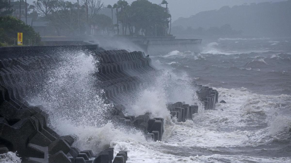
A typhoon moving at bicycle speed began dumping rain on southern Japan on a path that will bring strong winds, high waves and significant rainfall to most of the country, prompting weather officials to issue the highest-level warnings Wednesday (August 28, 2024).
Three people were injured, and three others were missing due to a storm-related landslide and driving accident.
The Japan Meteorological Agency said Typhoon Shanshan is expected to reach southern Kyushu and possibly make landfall Thursday (August 29, 2024), and issued the highest-level warning for violent winds, high waves and heavy rain for the Kagoshima prefecture, as well as an emergency storm surge warning. It forecast up to 60 cm (23.6 inches) of rainfall in 24 hours for southern Kyushu.
Shanshan was about 120 km (75 miles) south of the southern island of Yakushima on Wednesday (August 28, 2024) morning as it headed north toward Kyushu, packing winds of up to 180 km (112 miles) per hour, according to the agency.
The warm, humid air around the typhoon and a separate high-pressure system caused heavy rain in the central Japanese city of Gamagori, where a landslide buried a house with five people inside. Two of them were rescued alive and workers were searching for the other three, according to the Fire and Disaster Management Agency.
“On the southern island of Amami, where the typhoon passed, one person was knocked down by a gust while riding a motorcycle,” the FDMA said.
Weather and government officials are concerned about extensive nationwide damage as the typhoon slowly sweeps up the Japanese archipelago over the next few days, threatening floods and landslides and paralysing transportation, businesses and other daily activity.

The government plans to amend the FCRA, introducing new regulations for NGO asset management and accountability for key functionaries.

The draft policy for “Responsible Digital Use Among Students”, released on Monday by the Department of Health and Family Welfare, has recommended that parents set structured routines with clear screen-time rules and prioritise privacy, safety, and open conversation with children on digital well-being.

Police Observer Sushant Kumar Saxena conducts surprise inspection at Shencottai police station, reviewing warrants and security arrangements ahead of elections.

Andhra Pradesh government to launch key projects in April, focusing on industrial growth and infrastructure development, says Nara Lokesh.

Lok Sabha refers the Corporate Laws (Amendment) Bill to a JPC amid opposition concerns over CSR provisions dilution.

SHG members in Kanniyakumari use snakes and ladders to raise election awareness and boost voter turnout.

Government accelerates consultations for early implementation of the Women’s Reservation Act to ensure women’s representation in 2029 elections.

CM A. Revanth Reddy distributes ₹1 crore insurance cheques to families of deceased Electricity department employees, enhancing financial security for workers.

The Bengaluru Traffic Police (BTP) registered 634 cases of drunk driving during a week-long special enforcement drive conducted across the city between March 16 and March 22.

GHMC intensifies action against property tax defaulters, seizing properties and offering a One Time Settlement scheme for payments.

CCB arrests three drug peddlers in Mangaluru, seizing ₹2.5 lakh worth of MDMA and other valuables.

TVK's 28 candidates in Puducherry include former BJP MLAs, a sitting Independent, and a retired police IG.

BRS submits notice on private member bill to Speaker