Ice patches on melting glaciers greater threat than thought: ISRO scientists
The Hindu
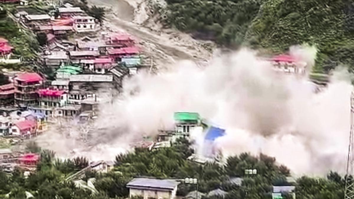
Researchers from the Regional (West) and National Remote Sensing Centres of ISRO have found that the presence of exposed ice patches on the Srikanta Glacier immediately before the floods of August 5 was a signal of ongoing deglaciation and a direct indicator in the landscape of the likelihood of such floods.
A new study by scientists from the Indian Space Research Organisation (ISRO), published in NPJ Natural Hazards, examines the August 5, 2025 flash flood that destroyed Dharali village in Uttarakhand and killed six people. It sheds light on how warming temperatures affect glaciers, especially exposed ice patches on retreating glaciers, and highlights the need to monitor glaciers using satellite images to provide early warnings of possible disasters.
The study, titled ‘Ice-patch collapse and early-warning implications from a Himalayan flash flood: emerging cryo-hydrological hazards under deglaciation’, concludes that the collapse of an ice patch on the glacier above Dharali is linked to deglaciation in the Himalaya.
The authors say the findings could help improve understanding of climate risk and disaster preparedness. The study shows that the flash flood was triggered by the collapse of an ice patch in the nivation area of the Srikanta glacier.
Nivation is defined as the erosion of the ground beneath and around a snow bank, primarily as a result of alternate freezing and thawing. This can form a nivation hollow, which gradually becomes deeper when snow repeatedly accumulates in the same place.
The study area lies in the upper Bhagirathi river basin in Uttarkashi district of Uttarakhand. It covers the ridge-to-valley system from the Srikanta glacier to Dharali village, located at a height of 2,650-2,700 m along the Bhagirathi river. The village lies downstream of the glacier-fed Khir Gad stream, which originates from the Srikanta glacier, flows through Dharali, and then joins the Bhagirathi river. The Khir Gad divides Dharali into right- and left-hand bank settlements, increasing its risk of flash floods.
The region has a documented history of extreme events, including the large landslides that brought down massive boulders during the June 2013 Himalayan floods. The researchers used satellite observations, high-resolution topographic analysis, and visual records to reconstruct the sequence of events linking unstable glacier ice to the sudden flood.

Chief Secretary K. Ramakrishna Rao's service extended by three months, ensuring continuity in Telangana's administration during crucial planning.

Meta challenges Delhi HC ruling on CCPA fine for walkie-talkie sales, arguing Facebook is not an e-commerce platform.

In a bid to boost domestic manufacturing of solar ingots and wafers - the constituents of solar cells that are then fitted on solar panels - the Ministry for New and Renewable Energy (MNRE) has said that from June 2028, only ingots and wafers made in India would be eligible for domestic projects.

Karnataka's Eva Nammava Bill aims to prevent honour killings and caste-based crimes, ensuring freedom of choice in marriage.

Water level in Mullaperiyar dam was 114.15 feet

Minister D.Sridhar Babu on Wednesday showcased Telangana to a visiting Slovenian delegation, highlighting investment opportunities the State offers across key sectors such as Life Sciences, automobiles and IT.

Delhi HC delays jail time for Rajpal Yadav in cheque bounce cases after substantial payment; next hearing set for April 1.

Tamilaga Vettri Kazhagam chief Vijay dismisses reports of TVK likely joining the National Democratic Alliance (NDA) for the 2026 Assembly elections in Tamil Nadu, asserts there is no compromise in his party’s stand on “secular social justice” principles.

Dr. Rakesh Gupta urges states to identify remaining HIV cases in India to transform the nation into 'Suraksha India'.

A Supreme Court ruling warns Tamil Nadu candidates about government contract pitfalls ahead of the 2026 Assembly elections.

State Bank of India chairman Challa Sreenivasulu Setty laid the foundation for Telangana Grameena Bank’s new head office in Hyderabad, aimed at strengthening its administrative capacity and operations.

Excise inspector, teacher arrested by ACB in bribery and benami transactions case

Police and doctors emphasize helmet use for road safety, distributing helmets and promoting awareness to prevent injuries and save lives.