China is mapping the ocean floor as it prepares for submarine warfare with the U.S.
The Hindu
China is extensively mapping ocean floors to enhance submarine warfare capabilities against the U.S. and allies across key oceans.
China is conducting a vast undersea mapping and monitoring operation across the Pacific, Indian and Arctic oceans, building detailed knowledge of marine conditions that naval experts say would be crucial for waging submarine warfare against the United States and its allies.
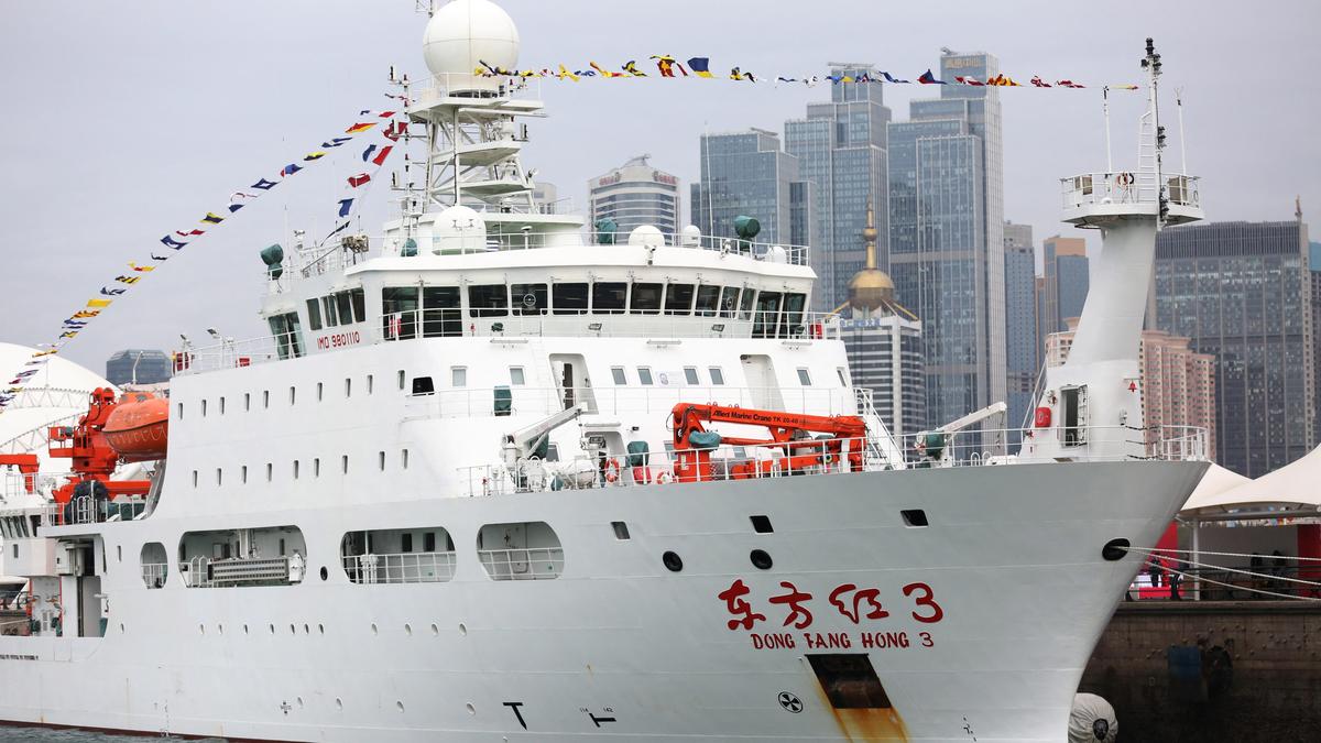
In one example, the Dong Fang Hong 3, a research vessel operated by Ocean University of China, spent 2024 and 2025 sailing back and forth in the seas near Taiwan and the U.S. stronghold of Guam, and around strategic stretches of the Indian Ocean, ship-tracking data reviewed by Reuters shows. In October 2024, it checked on a set of powerful Chinese ocean sensors capable of identifying undersea objects near Japan, according to Ocean University, and visited the same area again last May. And in March 2025, it criss-crossed the waters between Sri Lanka and Indonesia, covering approaches to the Malacca Strait, a critical chokepoint for maritime commerce.
According to the university, the ship was carrying out mud surveys and climate research. But a scientific paper co-written by Ocean University academics shows it has also conducted extensive deep-sea mapping. Naval-warfare experts and U.S. Navy officials say the type of deep-sea data being collected by the Dong Fang Hong 3 – via mapping and placement of sensors in the ocean – is giving China a picture of the subsea conditions it would need to deploy its submarines more effectively and hunt down those of its adversaries.
The Dong Fang Hong 3 isn’t operating alone. It is part of a broader ocean mapping and monitoring operation involving dozens of research vessels and hundreds of sensors. In tracing this effort, Reuters examined Chinese government and university records, including journal articles and scientific studies, and analysed more than five years of movement by 42 research vessels active in the Pacific, Indian or Arctic oceans using a ship-tracking platform built by New Zealand company Starboard Maritime Intelligence.
While the research has civilian purposes – some of the surveying covers fishing grounds or areas where China has mineral prospecting contracts – it also serves a military one, according to nine naval-warfare experts who reviewed Reuters’ findings.
To gather information about underwater terrain, research vessels map the sea floor while traveling back and forth in tight lines. The tracking data shows that type of movement by the vessels Reuters tracked across large sections of the Pacific, Indian and Arctic oceans.

Karnataka has entered a state of demographic transition where a large working-age population will no longer be enough to drive economic growth, and future gains will depend on how productively people are employed, the ‘State of Working India 2026’ report said.

Key demands in Sulur Assembly constituency include reviving the powerloom sector, addressing farmers' needs, and protecting River Noyyal.

Kodihalli urges Karnataka CM to allocate ₹10,000 crore revolving fund for seamless procurement of farm products under MSP scheme.

Kerala's political parties continue to marginalize women candidates, highlighting a troubling disconnect between gender demographics and representation.

The High Court of Karnataka on Tuesday ordered the issue of a notice to the State government on a PIL petition, which had complained about disturbances caused to people residing in the localities around the National Public School situated in Rajajinagar 5th block due to use of loudspeakers with high volume in the school and parking of school buses in residential areas.

China is extensively mapping ocean floors to enhance submarine warfare capabilities against the U.S. and allies across key oceans.

AIADMK's 2026 manifesto promises free rations, women's benefits, education reforms, and economic growth initiatives for Tamil Nadu.

The vehicle towing drive will soon resume in the city to ease traffic congestion. The Bengaluru Traffic Police (BTP), in coordination with the Greater Bengaluru Authority (GBA), is set to relaunch the vehicle towing drive across the city shortly to tackle traffic congestion and illegal parking.

Panic buying, not shortage, is leading to long queues at Hyderabad petrol pumps.

District Collector urges collective action against TB during World TB Day rally, highlighting screening efforts and patient support initiatives.

DMK finalises seat-sharing for the 2026 Tamil Nadu Assembly elections, contesting 175 seats with allies DMDK and VCK.

Collector V. Saravanan and Police Commissioner Kamini promote voter awareness through outreach programs and traditional events in Tiruchi.

Mysuru DC stresses precautionary measures to reduce road accidents, urging officials to identify and address high-risk areas.