Low pressure in Bay of Bengal: IMD issues a week’s rain forecast for A.P.
The Hindu
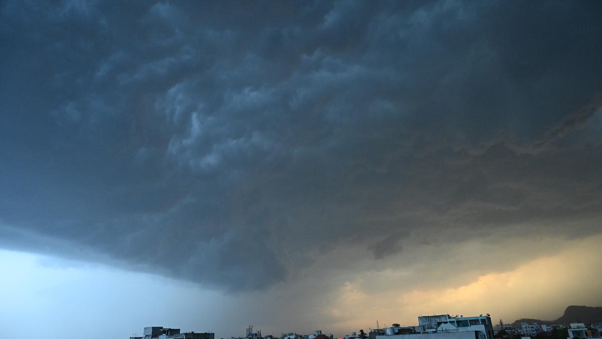
IMD forecasts rain and thunderstorms in Andhra Pradesh till April 14 due to cyclonic circulation over Bay of Bengal.
The India Meteorological Department (IMD) on Monday issued a rain and thunderstorm forecast for the State for the next one week till April 14.
Light to moderate rain at a few places is likely across the three regions of North and South Coastal Andhra Pradesh and Rayalaseema. The daytime temperature is expected to rise gradually by 2-4 degree Celsius in the three regions before seeing a dip.
The change in the weather is brought about by an upper air cyclonic circulation over southeast Bay of Bengal, under the influence of which a low-pressure area formed over south Bay of Bengal at 8.30 a.m. on Monday, according to the IMD bulletin.
An associated cyclonic circulation is extending up to 5.8 km above mean sea level and is likely to move northwestwards over southwest Bay of Bengal till April 8. Thereafter, it is likely to move nearly northwards over westcentral Bay of Bengal.
There is also a trough running from the above cyclonic circulation over southeast Bay of Bengal to south Tamil Nadu that extends up to 1.5 km above mean sea level.
Already, some parts in the State received light to moderate rain on Monday. According to the data compiled by the Andhra Pradesh State Development Planning Society(APSDPS) as of 7 p.m., Nagulavaram in Palnadu district received 30 mm rainfall, SRM University in Mangalagiri received 24 mm, Rachapanukulu in Alluri Sitarama Raju district recorded 21 mm, Tadepalli in Guntur recorded 19 mm, Vijayawada recorded 5 mm and Suratpalle in Tirupati recorded 7 mm.
The Andhra Pradesh State Disaster Management Authority has asked farmers to take all precautionary measures as there is a likelihood of a few areas receiving rain accompanied with thunderstorms, gusty winds and lightning.

Puducherry Assembly elections test the INDIA bloc's unity as parties file nominations amidst seat allocation uncertainty.

T.N. CM Stalin advocates for constitutional safeguards to maintain state representation in delimitation amid women’s reservation discussions.

Rohit Pawar files complaint in Bengaluru alleging conspiracy in Ajit Pawar's air crash; Maharashtra police had refused FIR.

Armed extremists attack Mongkot Chepu village again, firing on students and injuring civilians amid rising tensions in Manipur.

TGNPDCL bags ‘Governance Now’ award

Perundurai's industrial growth faces challenges of pollution, water scarcity, and healthcare, impacting residents ahead of the 2026 elections.

The Travancore Devaswom Board asserts that courts should respect community beliefs in its Supreme Court submission on Sabarimala's entry issue.

Karnataka cancels Deendayal Upadhyay event at KSOU due to protocol violations, citing inconsistency with university objectives.

Illegal pickle unit busted in Hyderabad, one arrested; unhygienic stock worth ₹3 lakh seized

Karnataka has entered a state of demographic transition where a large working-age population will no longer be enough to drive economic growth, and future gains will depend on how productively people are employed, the ‘State of Working India 2026’ report said.

Key demands in Sulur Assembly constituency include reviving the powerloom sector, addressing farmers' needs, and protecting River Noyyal.

Kodihalli urges Karnataka CM to allocate ₹10,000 crore revolving fund for seamless procurement of farm products under MSP scheme.

Kerala's political parties continue to marginalize women candidates, highlighting a troubling disconnect between gender demographics and representation.