Assam, Arunachal CMs agree to realign border based on 1960 papers
The Hindu
Both States have been involved in a dispute over 123 villages
The boundary line shown on 29 toposheets by a high-powered committee in 1960 will be taken as the basis for the realignment of the Arunachal Pradesh-Assam boundary towards resolving decades of dispute.
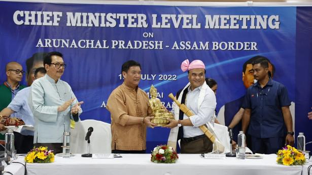
Assam Chief Minister Himanta Biswa Sarma and his Arunachal Pradesh counterpart Pema Khandu on Friday signed the Namsai Declaration for minimising the inter-State boundary dispute involving 123 villages. A list of these villages had been placed before a local commission by Arunachal Pradesh on December 26, 2007.
Namsai is the headquarters of Namsai district in southern Arunachal Pradesh.
“The boundary line delineated and signed on 29 toposheets by the High-Powered Tripartite Committee as notified boundary in 1960 would be taken as the basis for the realignment of boundary by both the States,” the declaration read.
Present-day Arunachal Pradesh, which attained Statehood in February 1987, used to be the North East Frontier Tract, administered by the Governor of Assam as an agent of the President of India. It was renamed North East Frontier Agency and brought under the Central government’s control in 1954.
According to the declaration, all border issues between Assam and Arunachal Pradesh will be confined to those raised before the local commission in 2007.

T. Jeevan Reddy resigns from Congress after 42 years, criticizing party leadership and the influence of defectors.

Kanniyakumari Collector inspects vulnerable and sensitive polling stations

Westbrook: Opening Doors to your Child’s Best Start

The Mangaluru Chapter of the Indian National Trust for Art and Cultural Heritage (INTACH) organised a special lecture in memory of Rashtrakavi Manjeshwara Govinda Pai on Monday.

Hyderabad's Buddhavanam will host the World Buddhist Peace Conference 2026, attracting delegates from 22 countries to promote peace.

The Mysuru City Corporation (MCC) has set an ambitious revenue target for 2026-27, projecting significant increases in property tax, trade licences, and non-tax revenues, while setting aside substantial funds for infrastructure, digitisation, and urban development.

NCSC reviews the reservation policy at Kalpakkam's atomic energy units, ensuring effective implementation and addressing concerns with officials.

Shivamogga Deputy Commissioner Prabhulinga Kavalikatti stated that the philosophy of the 12th-century Vachanas has served as a daily guiding principle in his role as an officer.

CM Siddaramaiah says he presented the State Budget at an "auspicious" time, owing to pressure from family and officials.

India's first open-source psychiatric disorders database, CALM-Brain, launched in Bengaluru, aims to enhance understanding and treatment of mental health issues.

Political parties in Tamil Nadu ramp up their election strategies in high-tech war rooms, focusing on youth engagement and real-time responses.

‘Follower’ dives into the heated border dispute between Karnataka and Maharashtra in Belagavi while tackling the messy world of social media and its impact on friendships

India's NavIC satellite system faces setbacks, limiting its security capabilities amid concerns of reliance on foreign navigation systems