A 100 years and Hyderabad turns into Urbs Humungous
The Hindu
A 100 years and Hyderabad turns into Urbs Humungous
June 2 marks 11 years of the formation of Telangana. It also marks 218 years of the creation of Secunderabad. Between these two dates, a post-Independence one and a pre-colonial one, is the story of the explosive growth of an inclusive city that is now Brand Hyderabad. A city that spells biryani, chai, chips, code, and rings of circular roads.
Hyderabad was a 132 sq km city with 4,04,187 souls, inside a walled area with 14 gates in 1921 and was the fourth largest city in India. More than a 100 years later, Hyderabad is an urban sprawl of 1,451 square kilometres with 1,13,38,000 people ringed within a circular road with 21 interchanges and is the sixth largest city in the country. A growth of 999.24% in terms of land area and a population that has grown by 2705.13%.
In the process, the city has changed names from Golconda to Hyderabad to Secunderabad to Cyberabad and now the Future City envisioned by Chief Minister A. Revanth Reddy. The rulers and planners have come and gone but the trajectory of the growth of the city has been exponential. The movers and shakers for the city of Hyderabad have been a legion since the time of Mohammed Quli Qutb Shah and Mir Momin, continuing with Mir Osman Ali Khan, M. Visvesaraya, Mehr Ali Fazil, Mohammed Fayazuddin and Mehdi Nawaz Jung.
Then there were later day politicians who left their stamp on the city — N. Chandrababu Naidu, Y.S. Rajasekhara Reddy, K.T. Rama Rao and now A. Revanth Reddy. There also have been countless other bureaucrats and technocrats who have left behind a legacy.
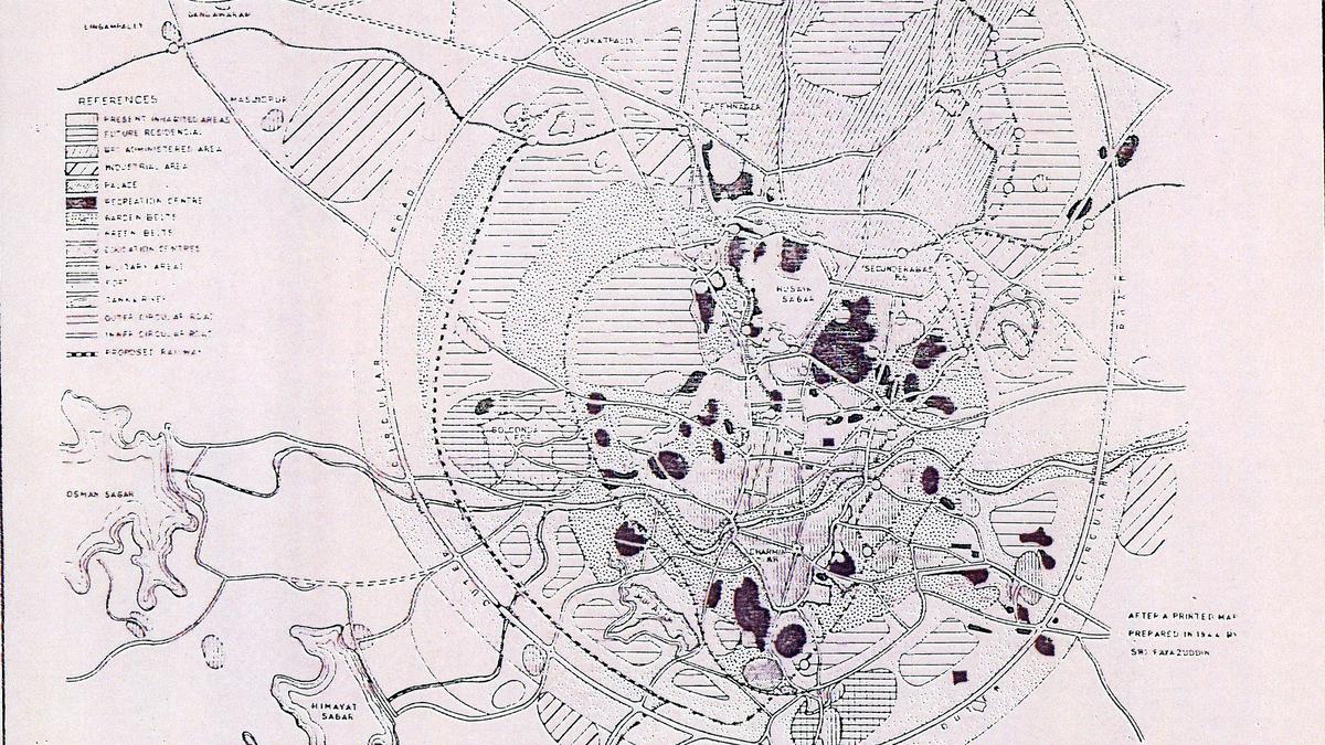
“Cities grow organically with nudges for change in a particular direction. But some areas of the city have developed too rapidly discarding principles of planning like in Cyberabad. Jubilee Hills was a planned residential area but was turned into something else. Similarly, Musi beautification and Imlibun park were planned earlier but we are coming to that after a detour,” says historian and engineer Sajjad Shahid. “Coupled with that there was no sanctity to a master plan. There were hundreds of notices of change in land use undoing the master plan,” says Mr. Shahid.
“Geography, topography, history and culture have driven Hyderabad’s planning. It was a planned city in Hyderabad state. There was planning till 1956. Not just Hyderabad but areas like Karimnagar, Adilabad, Warangal and other cities were planned and nurtured,” says Anuradha Reddy linking the earlier planned cities to the outer walls that enclosed Hyderabad and Warangal.
But the walls of planning made way for roads when Hyderabad was born with Charminar as its centrepiece and four radiating roads connecting it to the port city of Machilipatnam. The 1591 plan with the east-west and north-south axial roads made way for circular roads.

MLC Kishore Kumar Puttur criticizes the State for poor implementation of the Centre's health scheme for senior citizens.

Karnataka's Health Minister announces redeployment of specialists to taluk hospitals to reduce neonatal mortality rates effectively.

Celebrate IPL's start and Polly Umrigar's legacy, reflecting on cricket's evolution and the enduring impact of its pioneers.

BJP accuses Congress and Rahul Gandhi of endorsing an ‘anti-India’ USCIRF report undermining India's global image.

Education Ministry proposes UGC-like funding under Shiksha Adhishthan, raising concerns about centralization and public university financing.

Shivraj Singh Chouhan defends the new rural jobs Act, dismissing opposition protests as ineffective and highlighting increased funding and worker protections.

Supreme Court questions why heirs can't access unclaimed funds of deceased depositors, urging government to develop a disclosure policy.

Karnataka High Court demands LPG supply details amid state restrictions, threatening Bengaluru's restaurants and livelihoods.

Shorts News:UN body investigating deadly strike on Iranian girls school

Moodbidri police inspector suspended pending inquiry over allegations of misbehaviour and inappropriate conduct towards women.

The State currently hosts more than 880 GCCs, up from around 500 GCCs in 2021.

Transgender and intersex activists march to Lok Bhavan, protesting the regressive Transgender Persons Bill and demanding its withdrawal.

Hyderabad's LGBTQIA+ community opposes the Transgender Amendment Bill, stressing dignity over identity verification and highlighting economic and medical concerns.