ISRO’s CARTOSAT-3 images show damages caused by earthquake in Myanmar
The Hindu
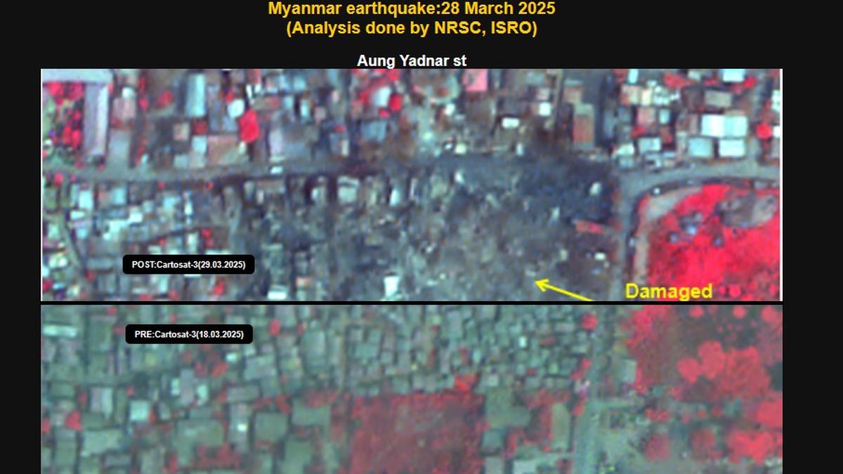
ISRO's CARTOSAT-3 imagery reveals earthquake damage in Mandalay and Sagaing cities, including collapsed landmarks and infrastructure.
ISRO has released images captured by its earth imaging and mapping satellite, CARTOSAT-3 showcasing the damages caused by the earthquake in Myanmar on March 28.
The post-disaster Cartosat-3 imagery was acquired by ISRO on March 29 over the cities of Mandalay and Sagaing in Myanmar, it said.
Additionally, the pre-event Cartosat-3 data acquired on March 18 covering the same area was referred for change analysis and assessment of damage, the space agency said.
CARTOSAT-3 is a third generation agile advanced satellite having high resolution imaging capability.
"Significant damage to infrastructure in Mandalay city was observed, with major landmarks such as Sky Villa, Phayani Pagoda, Mahamuni Pagoda and Ananda Pagoda, University of Mandalay and several others suffering either complete or partial damage. In Sagaing city, damage was observed in the Ma Shi Khana Pagoda, along with several monasteries and other buildings," the ISRO said in a statement.
According to ISRO, as seen from the imagery, the earthquake caused the complete collapse of the historic Ava (InnWa) Bridge on the Irrawaddy River near Inn Wa City. Cracks, ground ruptures in flood plains of Irrawaddy river with associated liquefaction was also observed.
In the statement, the space agency noted that an earthquake of magnitude 7.7 struck Myanmar on March 28 followed by strong aftershock of magnitude 6.4. The epicenter is located at 22.013° N 95.922° E at a depth of 10 km near Sagaing-Mandalay border.

Record sales of sheep and goats at Manapparai cattle shandy surge despite MCC cash restrictions ahead of Ramzan.

NCC cadets participated in a community development walkathon and awareness skit, organised by Ramaiah University and sponsored by 40 Karnataka Battalion.

Join a free webinar on March 20 exploring patient-centric, tech-enabled TB care ahead of World Tuberculosis Day.

Gold worth ₹2.5 crore seized in Nilgiris due to lack of documentation during transport to private jewellery stores.

Explore the inspiring journey of Geetha Kannan, a national-level Paralympic swimmer and junior cooperative auditor, overcoming challenges with resilience.

BJP's Dilip Ghosh claims Mamata Banerjee is trapped in Bhabanipur, facing tough election challenges from Suvendu Adhikari.

DMK MP R. Girirajan petitions Madras High Court for ED to investigate AIADMK leaders for money laundering linked to corruption cases.

V.D. Satheesan urges the Election Commission to remove LDF government hoardings, citing violations of the Model Code of Conduct.

Featuring Sanjay Dutt and Nora, the Kannada original version of the song, titled ‘Sarse Ninna Seraga Sarse’, was slammed for its “oscene” lyrics by fans and people from film fraternity on social media

Supreme Court questions West Bengal's claim that ED lacks rights to challenge obstruction during I-PAC raids by Chief Minister.

Madras High Court bans unauthorized Dhurandhar merchandise sales on major platforms and orders ISPs to block pirated content.

Ex-AAP councillor Tahir Hussain seeks one-month interim bail on medical grounds to undergo surgery related to a hernia.

BJP leader Dilip Ghosh aims to secure over 1 lakh votes, promising a victory margin greater than in 2016 elections.