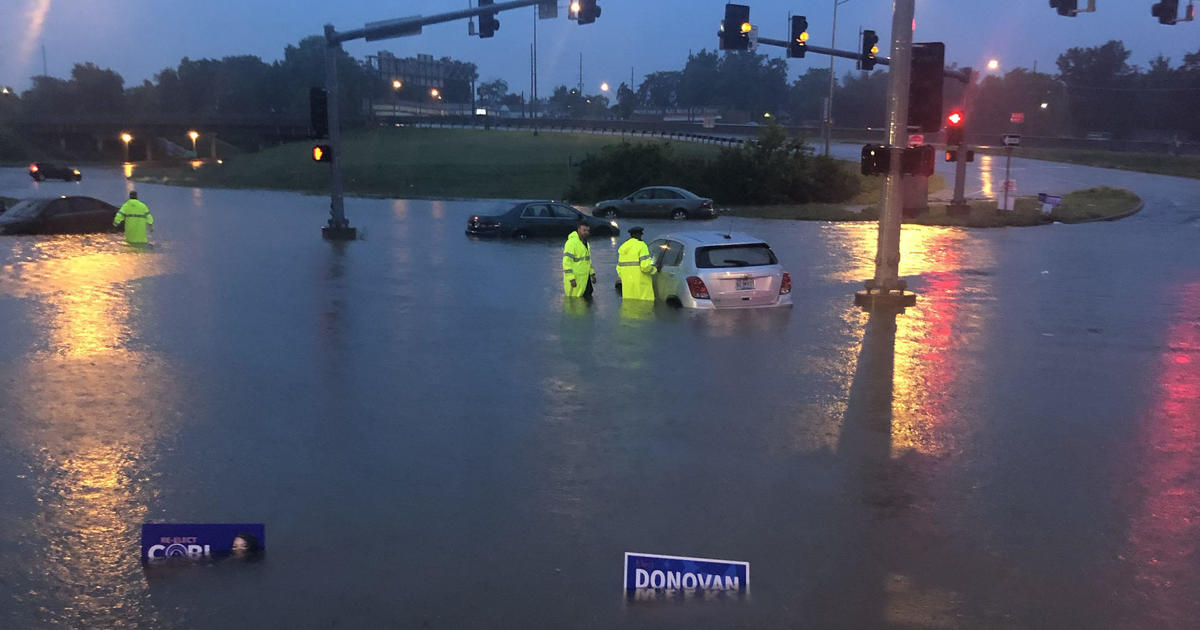
"Historic rainfall" brings "life-threatening" flash floods in St. Louis
CBSN
Record-high precipitation is soaking St. Louis, leading to what the National Weather Service called "life-threatening" flash flooding. Though no one has been reported dead, authorities said they were carrying out multiple rescues — and photos showed cars almost entirely submerged in the water.
Massive thunderstorms that hit St. Louis overnight prompted a "historic rainfall event," per the National Weather Service, which in turn caused "widespread flash flooding" throughout Tuesday morning. As of 7 a.m. local time, the city had shattered its daily rainfall record, reporting 8.06 inches of rain in just seven hours, the Weather Service said. The previous record, set in August 1915 after the Galveston hurricane, was 6.85 inches.
The rainfall led the National Weather Service to declared a flash flood emergency for St. Louis early Tuesday morning — which, per the Weather Service, describes the "EXCEEDINGLY RARE situations when extremely heavy rain is leading to a severe threat to human life and CATASTROPHIC DAMAGE from a flash flood is happening or will happen soon."

Fentanyl was found inside Barbie doll packages being sold at a discount store in Missouri, police said on Saturday. In:

CBS News contributor Arthur C. Brooks is the author of a new book, "The Meaning of Your Life: Finding Purpose in an Age of Emptiness." This morning, he's charting an unlikely path to happiness:

When gauging a war, Americans consider at least two important things: what the goals are overseas and its impact back home. In:

The peace and tranquility of Muir Woods, just north of San Francisco – home to 500+ acres of old-growth redwoods – make it just about the last place you'd expect to find a fight brewing. "The fact that they're taking down whole groups of signs about climate change and our nation's history is disappointing, and embarrassing," said retired U.S. Park Ranger Lucy Scott In:

We share our planet with maybe 10 million species of plants, animals, birds, fish, fungi and bugs. And to help identify them, millions of people are using a free phone app. "Currently we have about six million people using the platform every month," said Scott Loarie, the executive director of iNaturalist, a nonprofit.

Washington — As voters gear up for the midterm elections in November that will decide control of the House and Senate, the Supreme Court is set to weigh Monday whether states can count mail ballots that are postmarked by, but arrive after, Election Day.

It was in June 2020 when Linda Dane learned the disturbing circumstances of how her long-lost brother Gary Herbst's skull had been found by a dog in rural Barron County, Wisconsin. In:

A possible meteorite crashed into a Houston area house on Saturday night, tearing through the roof and two stories of the home, officials said. In:

The Senate on Saturday blocked an amendment that would ban transgender athletes from playing in women's sports, rejecting one of President Trump's priorities as he pressures Congress to act on a broad voting bill.

Robert Mueller, a former FBI director who led the investigation into allegations of Russian meddling in the 2016 election, has died, multiple sources told CBS News on Saturday. He was 81. In:

Kendra Duggar was arrested for misdemeanor charges including endangering the welfare of a child and false imprisonment, according to online records. The charges come a day after her husband Joseph Duggar was charged with molestation. In:

At ski resorts across the West this winter, viral images showed chairlifts idling over brown terrain in places normally renowned for their frosty appeal. Iconic mountain towns like Aspen, Colorado, and Park City, Utah, were seen with shockingly bare slopes, as the region endured a historic snow drought that experts warn could bring water shortages and wildfires in the months ahead. In:

The NCAA accused online sportsbook DraftKings of trademark infringement associated with the association's men's and women's basketball tournaments and filed a complaint in federal court seeking an emergency restraining order. In: