Hurricane season: How NASA tracks the dangerous storms
Fox News
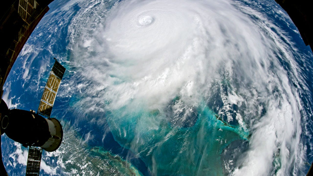
With an "above-normal" Atlantic Hurricane Season underway, researchers at NASA have partnered with the National Oceanic and Atmospheric Administration (NOAA) and other organizations to provide critical forecast data that could potentially save lives.
In August 2020, the agency utilized satellite data to monitor Hurricane Laura, which made landfall along the Louisiana and Texas coastline, bringing winds at speeds of up to 150 mph. NASA's Earth Applied Sciences Disasters Program processed and analyzed that data before, during and after the hurricane made landfall in order to create flood maps, locate damaged areas and assess coastal erosion.
Burger King plans a nationwide rollout of its Patty AI tool, which analyzes headset conversations to improve service and operations.

A quicksand warning is issued by National Park Service for Glen Canyon National Recreation Area in Arizona and Utah after hazardous areas are found near shorelines and drainages.

Pizza before tomatoes? Ancient Rome's version of America's favorite food looked nothing like today's
Ancient Rome pizza at Hungary restaurant features no tomatoes or mozzarella, using garum fish sauce and olive paste. Neverland Pizzeria's dish is limited-edition.

House China Committee Chairman John Moolenaar calls on NSF to pause $67 million research security initiative, citing concerns universities have ties to Chinese military institutions.

New research suggests muscle strength may be more important than aerobic exercise for longevity in women over 60, with surprising findings about health outcomes.

Airports advise travelers to arrive 3-4 hours early as the DHS shutdown creates severe delays. Website and app operations are paused, leaving travelers without updates.

Cannabis compounds CBD and CBG significantly reduced liver fat in Hebrew University research, offering potential treatment for metabolic dysfunction-associated steatotic liver disease.

Rep. Zoe Lofgren backed SJSU's lawsuit against Trump administration over alleged Title IX violations involving transgender volleyball player controversy.

Health Secretary Robert F. Kennedy Jr. has called out Starbucks and Dunkin' over high-sugar frozen coffee drinks as experts weigh in on medical risks and daily sugar limits.

SBA Administrator Kelly Loeffler announced an expanded policy on Friday banning foreign nationals from all Small Business Administration guaranteed loan programs, prioritizing American citizens.

A registered dietitian in Virginia recommends "Salmon Mondays" as a simple way to boost omega-3 intake. Research suggests many people fall short of recommended levels.

Firefighters may lose 10 years of life due to toxic exposure and stress. Experts share heart health, sleep and longevity tips to extend careers.

A newly announced discovery at Panama's El Caño site has revealed a 1,000-year-old tomb filled with gold artifacts, including chest plates and bracelets.