Heavy snowfall across northwestern Ontario leads to a number of closures, cancellations
CBC
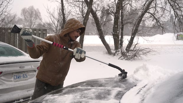
While the first day of spring is less than a month away, people in northwestern Ontario are still brandishing their snow shovels after being pelted with a winter storm overnight.
Snowfall warnings were issued for much of the region Thursday, spanning from the Ontario-Manitoba border to Thunder Bay. Between 15 and 25 centimetres of snow were expected.
As of Friday morning, the warnings remain in effect, according to Environment and Climate Change Canada.
The flurries have led to a number of closures and cancellations in Thunder Bay:
Meanwhile, a number of school buses were cancelled in the Superior–Greenstone area, along with White River and Hornepayne. Further west of the city, all school buses were cancelled in Dryden, Red Lake, Ear Falls, Vermillion Bay, Ignace and Upsala.
Trudy Kidd, a meteorologist with Environment and Climate Change Canada, told CBC News the snow is expected to subside in Thunder Bay by noon on Friday.
"It might just be light after that, but the bulk of it will have fallen by mid-morning," said Kidd.
Precipitation levels have been normal in northwestern Ontario in February, she said.
"It has been a totally different story here in southern Ontario. We're getting a lot more snow than usual. But I'm seeing it's not so much the case for northwestern Ontario," Kidd said.
As for the weekend, she said, a ridge of high pressure means people can expect cold but sunny temperatures and less weather activity.
"Our next couple low-pressure systems are actually missing northwestern Ontario. They're impacting southern Ontario again," said Kidd.

Premier Doug Ford says his government plans to give Toronto's Billy Bishop Airport special designation that would allow the province to bypass municipal and provincial laws as it pushes to expand the runway downtown.

Jenelle Hughes says she worries every time her two older children take their car to get to Fanshawe College in London, Ont., from their home in Dutton.

Oil prices fell Monday morning after President Donald Trump said the U.S. would hold off on striking Iran’s energy infrastructure amid productive talks between the two countries.

While spring technically started late last week, Newfoundland and Labrador isn't free from winter weather just yet.

The Sudbury School Bus Consortium is suspending all school buses in Greater Sudbury as the community continues to clean up following a major storm.

Two large corporate landlords owning a combined 9,008 rental units in Halifax are reporting smaller annual increases in their average rents for 2025 than the previous year.

The Holt government has reached a deal with Ottawa on compensation for tens of millions of dollars in lost sales tax revenue from the Christmas season in 2024.

The government of Saskatchewan has announced plans to reduce the length of non-resident game bird hunting licences to combat illegal guiding.

An 87-year-old Alberta man is fighting extradition to the United Kingdom to stand trial for historical allegations of physical and sexual assault involving minors.

Eight casinos across southwest B.C. have been sold to First Nations in the last two years, with the province's gambling scene set to be reshaped as a result.

Hamilton hosts the Junos Sunday, and the musical awards show is bringing tourists, musicians, concerts and a ton of themed events to the city this week.

The multi-million-dollar deal at the heart of a high-profile fight between the Canadian government and one of the world’s biggest carmakers contains multiple clauses about the company’s footprint in Ontario, according to a copy obtained by CBC Windsor.

In recent months, Calgary police have carried out three day-long safety blitzes, parading out dozens of officers to flood an area with their increased presence — at least, temporarily.