Old maps reveal how much of Point Pleasant Park has been lost to erosion
CBC
Jonathan Fowler has been walking the paths of Point Pleasant Park in Halifax for decades, since he was a little kid.
Over time, he's noticed changes.
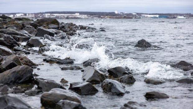
"The shoreline seems to be moving inland, and particularly after big storms," he says. "It just appears that we're losing more of the park to the ocean."
Fowler, an archaeologist and professor of anthropology at Saint Mary's University, decided to put his observations to the test.
Using a combination of old maps, aerial photos and laser-imaging technology, he is trying to measure how much the ocean has encroached on the land in the park.
Fowler has studied maps of Point Pleasant Park dating back centuries, but he discovered that most of the earliest ones were not suitable for his project.
"We've got maps from French cartographers who were doing this in the very early 1700s, it's just that they weren't surveying that area super carefully," he says.
"It needs to be of really high quality, and by that I mean really carefully surveyed at a large scale. And unfortunately, most of the maps just aren't."
The earliest map that's detailed enough is a British military survey plan of the park from 1858 that even shows the low and high tide marks.
Traces of that survey work still linger in the park today — small etchings, no bigger than the palm of a hand, made in rocks that indicate survey points.
Fowler uses fixed points in the park that have not changed in a couple of centuries, such as the Prince of Wales Tower, the intersection of certain paths, monuments, forts and even outcroppings of bedrock, to analyze how things have changed along the shore.
On a recent snowy day, Fowler trekked around the park with a group of his students, using a GPS to collect location data. Those data points allow him to digitally stitch together current locations with old maps and aerial photos to make comparisons.
His preliminary data suggests the coastline has changed by about 10 metres in some locations from about 1860 to today. Fowler says some places in the park, such as the southeastern area near the Point Pleasant Battery, appear to be more affected than others.
As he presses forward with his work, the municipality is eyeing making changes to improve shoreline resilience at the park.

The Swale Watchers plan to keep watching.

In a smaller city like Prince Albert, Ramadan can feel different.

About 125 people came out for a town hall meeting on health care in Charlottetown Monday night.

This is the second of two-part CBC News report on Taser use by Edmonton police. To read the previous story, click here.

A Merritt, B.C., father is urging parents to be on the lookout for ticks while the weather warms up, after his six-year-old son was partially paralyzed by a tick bite last week.

About that heartbreaking loss to the U.S. at the 2026 Olympic women's hockey final last month, Sarah Nurse says, “that was the most fun I’ve had in a hockey game in a very long time.”

The U.S. government on Monday said electric vehicle (EV) maker Tesla and South Korea's LG Energy Solution had signed a supply agreement to build a $4.3 billion lithium iron phosphate (LFP) prismatic battery cell manufacturing facility in Lansing, Mich., with an expected production launch in 2027.

In one small town in Alberta, the assistant principal says teachers almost never meet alone with parents anymore.

Tens of thousands of customers are without power and four parts of Highway 401 are closed Tuesday morning as blasts of blowing snow hit the Ottawa-Gatineau area.

Melody Macsemchuk says volunteers at Grace Place in Thunder Bay, Ont., serve between 300 and 350 meals a day.

Groups of volunteers continue to search alongside police for a man who went missing in late January near Owen Sound, Ont., covering land on foot, and using drones for a view of the conservation area where his car was found.

Jessica Hay says her daughter Charlie loves to be included in everything — and a new accessible shopping cart at her local grocery store in Cornwall makes it possible for Charlie to come along for the ride.

The N.W.T. cabinet says it will review whether or not the territory needs an independent child and youth advocate after a motion by Range Lake MLA Kieron Testart calling on it to establish such a position was carried in the legislative assembly.