Northern Ontario farmer worries flooding could take his property and nearby homes
CBC
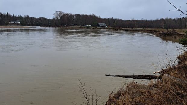
A fourth-generation farmer in northeastern Ontario worries the nearby Goulais River will eventually destroy his family farm and several homes downstream from his property.
Every spring Matt McDonald says part of his property is flooded by the Goulais River as water levels rise.
McDonald says his land has gradually eroded for years, and it's because of blasting that occurred in 1931, when his great-grandfather owned the farm.
"I know we're in the floodplain and I get all that," he said.
"That's all part of where we live. But when the government does things, like when I do things, I've got to take ownership for it."
What was then Ontario's Department of Highways blasted a channel at the Goulais River's edge to protect Highway 552 West from flooding.
The plan worked, but it had unintended consequences.
That new channel redirected the river directly to the McDonald family farm.
Two years later, in 1933, the department built a stone barrier to protect the farm.
Glynn Rouse, who was a member of the Goulais and District Local Services Board, wrote a letter in 2006 to Mike Brown, the Liberal MPP for Algoma-Manitoulin at the time, in which he voiced his concerns about the McDonald farm property.
In his letter, Rouse said that stone barrier proved sufficient for more than 20 years. But by 1963 it had eroded, at which point the province lined the property with shale rock to prevent further erosion.
That proved to be a short-term solution.
"At present it erodes 10 to 20 metres each year," Rouse wrote in 2006.
"It is the concern of Goulais residents that a breakthrough is no longer a matter of if, but when ... And the 'when' appears to be imminent."

Saskatoon city hall administration is planning to "refresh" the funding strategy for the proposed $1.2-billion downtown arena district amid a lack of commitments from higher levels of government.

A report of fraud tied to a walleye derby is under investigation after Montreal Lake Cree Nation said a participant allegedly violated derby rules and was asked to leave the fishing area.

An Edmonton architectural firm says it is in talks with the provincial government to potentially redevelop the former Royal Alberta Museum.

Does junior football have a future in Prince George?

People are descending upon the city for the dozens of events and live music performances this week as the Juno Awards are set to take place Sunday at Hamilton's TD Coliseum.

For nearly two decades, Amanda Loewen's world ended where the pavement did.

The notion that home ownership guarantees financial security in old age is being challenged by a recent survey.

The family of Nash Prystie has identified him as the man who died in an Ontario Provincial Police (OPP) shooting earlier this month north of Kenora, and is calling for more and quicker help for people with mental health challenges.

Playoff action in the Ontario Hockey League gets underway Thursday night for Guelph and Friday in Kitchener.

UPEI wants its faculty to sign on to an updated version of its sexual assault and discrimination policy, but the union that represents the school's academic staff says it wants the policies to be part of its collective agreement.

In Texas this week for a global energy conference, the federal natural resources minister is proclaiming "Canada is back" and ready to bolster its energy sector and grow exports.

Members of Parliament last year went on the fewest sponsored international trips in the last 15 years, excluding the height of the COVID-19 pandemic.

Ontario is running out of time to beef up rules that would crack down on negligent and misbehaving municipal politicians ahead of the next civic election, some experts and opposition critics warn.