Hurricane Idalia in 6 maps: Here's what the data shows
CTV
As Hurricane Idalia batters Florida's west coast, scientists are tracking when and where the storm will move next. Here are the details showing the hurricane's path this morning.
Hurricane Idalia has made landfall in the U.S. with "catastrophic storm surge and destructive winds" the National Oceanic and Atmospheric Administration says.
The storm is battering Florida's coast and was downgraded to a category three, from a category four, hurricane shortly before making landfall.
As of 7 a.m. EDT winds were blowing at 201 kilometres per hour forcing waves into the communities of the Big Bend region, where they could reach as high as 4.5 metres.
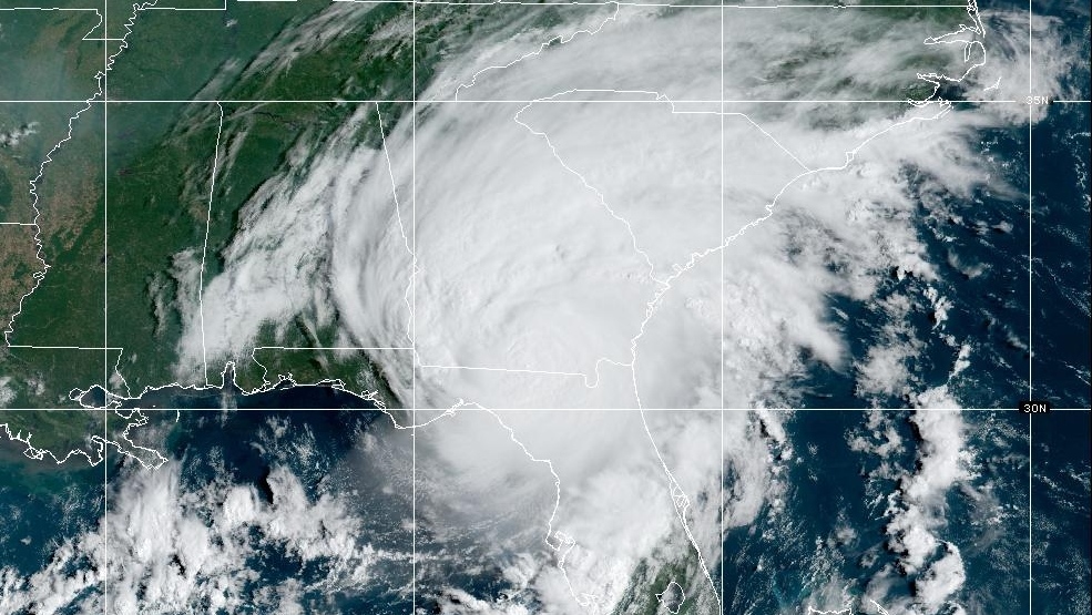
Here's what Hurricane Idalia looks like according to data from radar systems monitoring its destructive path. All maps and information are from the NOAA website tracking the hurricane.
The map above shows the hurricane at 8:11 a.m. EDT. The eye of the storm has crossed onto land, bringing with it strong winds, rain and lightning.
The colours show lightning flashes in the area every five minutes. Green is showing fewer flashes of lightning whereas red is for intense lightning episodes.
As the storm moved on land, lightning decreased.

Hawaii suffered its worst flooding in more than 20 years as heavy rains fell on soil already saturated by downpours from a winter storm a week ago, officials said Friday while warning that still more rain was expected during the weekend.

While Canada is well known for its accomplishments in space — including building the robotic arms used on the Space Shuttle and the International Space Station — the country still has no ability to launch its own satellites. This week, Ottawa committed nearly a quarter‑billion dollars towards changing that.

March is Liver Health Month, and while many people think about alcohol and diet when it comes to liver health, a growing risk factor is chronic hepatitis B.

It’s an enduring stereotype that Canadians are unfailingly nice, quick to apologize even when they have done nothing wrong. But an online urban legend claims the opposite of Canada’s soldiers, painting a picture of troops so brazen in their brutality that international laws were rewritten to rein them in.

Friday marks the first official day of spring in the northern hemisphere, but it will still feel like winter this weekend for many Canadians, as snow, sleet, rain and sub-zero temperatures are forecast across the country.

A social media post from the U.S. Food and Drug Administration this week shows a big-eyed macaque staring out from behind bars.

Young people in southeast England and beyond are lining up for the meningitis B vaccine after an outbreak killed two people, sparking supply warnings from pharmacies and raising broader questions about the best public health response to the disease.

Many wage earners are engaging in “microshifting,” a flexible scheduling approach that involves tackling job duties in short, productive bursts instead of a single nine-to-five stretch.

Tyson Atleo, a hereditary leader of the Ahousaht First Nation, says the creation of three new forestry areas to be managed by his community and two others on the west coast of Vancouver Island marks the realization of a long-standing promise.

As artificial intelligence continues to reshape industries worldwide, Canadian universities are emerging as key players – not only in developing technology but in teaching students how to use it responsibly.

Switching up your exercise routine does more than fight boredom. Engaging in varied forms of movement may significantly boost your longevity, according to research.

A seven-bedroom, five-bathroom home in Ottawa’s Rothwell Heights neighbourhood is currently the most expensive home on the market in the capital.

David Suzuki, the geneticist-turned-environmentalist, who is days away from his 90th birthday, reflected on his legacy as he prepared to release his latest book, “Lessons from a Lifetime,” which compiles photos and stories from his life, as well as testimonials written by those he inspired.