Snowpack levels in B.C. above normal, except Okanagan: River Forecast Centre
Global News
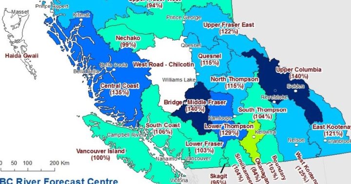
Snowpack levels across B.C. are 115 per cent of normal. The data ranges from 84 per cent in the Okanagan to 140 per cent in the Upper Columbia.
If it seems winter in B.C. has been snowier than usual, that’s because it is.
Data released by the B.C. River Forecast Centre this week shows that, on average as of Jan. 1, snowpack levels across the province are 115 per cent of normal.
According to the River Forecast Centre, the data is from its 51 manual and 86 automated snow-weather stations. The average ranges from a low of 84 per cent in the Okanagan to 140 per cent in the Upper Columbia.
Normal snowpacks (90 to 110 per cent) were measured for the Upper Fraser West, Lower Fraser, South Thompson, Boundary, Similkameen, South Coast, Vancouver Island, Skagit, Peace and Stikine regions.
Slightly above-normal snowpacks (110-120 per cent) were recorded in the North Thompson and Skeena-Nass.
The River Forecast Centre said regions with above-normal snowpacks (120-130 per cent) were the Upper Fraser East, Middle Fraser, West Kootenay and East Kootenay, while the Central Coast and Upper Columbia had well above-normal snowpacks (130-plus per cent).
Notably, the entire Fraser River basin is at 110 per cent.
For the Okanagan, last year’s snowpack at this time was much higher, at 132 per cent.

Members of Parliament are back in the House of Commons today, where the government is expected to face tough questions about new auditor general reports and the war in Iran.

Two Air Canada pilots are dead after their flight originating from Montreal collided with a fire truck at New York’s LaGuardia Airport Sunday night.

With more rain in the forecast, crews continue to deal with a mudslide earlier this week that covered a road in Coquitlam in debris, posing risk to Metro Vancouver's water supply.

A former BC Ferries CEO says the Queen of the North sinking remains ‘disturbing’ 20 years later. The ferry struck an island in Wright Sound on March 22, 2006. Two people died.

The 2026 Kraft Hockeyville top two contestants have been named. The winner receives $250,000 for ice rink upgrades, and the runner-up will receive a prize worth about $100,000.

The Office of the Parliamentary Budget Officer scrutinizes federal spending decisions and helps to cost out campaign proposals during elections.

Man’s best friend is proving to be a true lifeline. All across Saskatchewan, service dogs are providing essential, life-changing support every day.

Two days after the first day of spring, parts of Atlantic Canada and Quebec will see another blast of winter with Environment Canada forecasting several centimetres of snow.

UNESCO recognized several Maritime historical groups including the executive director of the Black Loyalist Heritage Centre for their work on the Black Loyalist archive.

Aid shipments are beginning to arrive in Cuba and a Russian oil delivery is expected this month, but fuel shortages remain critical.

Tensions flared as CAQ leadership rivals clashed over Quebec’s “third link” project in the first debate to replace Premier François Legault.

Toronto police have charged a 60-year-old man with second-degree murder in connection with the death of Xian Wei Shao, whose remains were discovered in a north end home last week.

Finance Minister François-Philippe Champagne says the government has found ways to cut spending by $60 billion but cautions that published spending cuts require important context.