Satellite imagery shows Nova Scotia wildfire smoke drifting to the U.S.
CTV
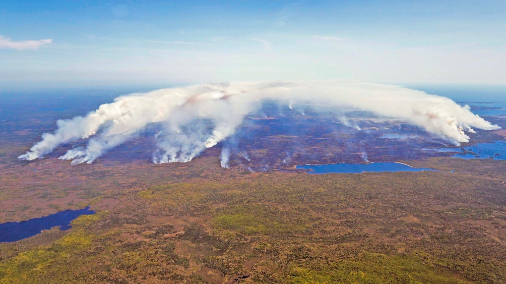
Imagery from National Oceanic and Atmospheric Administration (NOAA) satellites show wildfire smoke is drifting over from Nova Scotia to Northeast parts of the United States, as shown on Twitter.
Imagery from National Oceanic and Atmospheric Administration (NOAA) satellites shows wildfire smoke drifting over from Nova Scotia to northeastern parts of the U.S.
In the post shared on Twitter, NOAA says that the smoke will continue to bring hazy skies to most parts of the northeast again today.
Smoke from #wildfires in Nova Scotia, Canada has been drifting over the northeastern United States this week, as seen in this imagery via @NOAA's #GOESEast satellite yesterday. The smoke will continue to bring hazy skies to much of the Northeast again today. pic.twitter.com/PG3bzvAVCO
The smoke is leading to air quality alerts in parts of the U.S., with local weather reports warning that the hazy skies will be most visible approaching the time of sunset on Wednesday.
Outdoor air pollution is a major environmental health problem, according to the World Health Organization (WHO) and can lead to premature death.
Canada’s health guidelines for protection against wildfire smoke include limiting outdoor activity and strenuous physical activity, and drinking plenty of water to help the body cope with the smoke.
The current wildfires in Nova Scotia have reportedly covered 837 hectares as of today.


Peel Public Health says nearly 16,000 students in the region could be suspended due to incomplete immunization records.

On Thursday morning, 68-year-old Mava Brydges put the weight of a household refrigerator onto her back, lowered herself toward the floor and then stood up again.

At this month’s Milan Cortina Paralympics, some athletes competed in shorts, T-shirts and tank tops. One skier lamented “tropical” conditions and a snowboarder complained that soft, slow snow put him at a disadvantage. And some worried about their safety.

Ottawa is expected to announce $552 million in funding for academic research projects this morning.

Two people are dead after donating plasma at Winnipeg collection centres.

Divorce may call to mind shouting matches and seething emotions. But in some marriages, silence and suppression are the defining traits.

Major storms whipped up tornadoes that killed at least two people in northwest Indiana and leveled buildings in Kankakee, Illinois, authorities said Wednesday, as another round of rain, hail and strong winds made its way through the region.

Computer chip demand has skyrocketed this year and one Harvard professor points to AI as a potential cause.

Prince Edward Island has announced a major leadership change at the province’s health authority.

Commuters, residents and tourists who take to social media during warm months to complain about sweltering subway systems in New York, Boston and London should feel vindicated — new research says they aren’t alone.

A large portion of the country from Ontario to Newfoundland is bracing for a wet wintry weather mix on Wednesday, with some regions expected to see a “critical freezing rain event,” according to Environment Canada.

A massive space probe could plummet into Earth’s atmosphere as soon as Tuesday evening — years earlier than expected. And while most of the spacecraft will likely disintegrate in a flaming blaze during reentry, a few components could survive, according to NASA.