Marathon snowstorm continues Sunday into Monday for the Maritimes
CTV
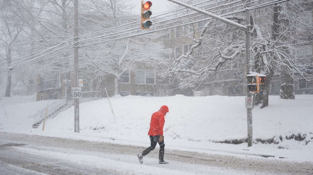
As parts of eastern Nova Scotia and eastern Prince Edward Island report snow amounts of 30 to 60 cm already down, there is more to come over the next few days.
As parts of eastern Nova Scotia and eastern Prince Edward Island report snow amounts of 30 to 60 cm already down, there is more to come over the next few days. Cancellations and impacts to travel services continue to add up in the region.
The ocean storm bringing snow to the region continues to be stalled off the Atlantic coastline of Nova Scotia. It will remain that way through Sunday before finally moving further away towards the northeast late on Monday.
On Sunday, the steadiest and heaviest snow will fall over central and eastern areas of both Prince Edward Island and Nova Scotia. Central areas of Nova Scotia may have a break, or lull, in the snow Sunday morning into afternoon before it picks back up again for a period of time Sunday evening.
By Monday morning, the remaining snow in the Maritimes will have become more intermittent and lighter. Bands of snow are expected to continue around Prince Edward Island and eastern areas of Nova Scotia, with periods of flurries for much of the remainder of the Maritimes.
Through the course of this multi-day snowstorm there will be some astoundingly high overall totals. By the end of Monday it is possible that parts of Cape Breton have totals in the range of 80 to 100 cm. Queens and Kings County, Pince Edward Island could have totals of 30 to 60 cm. Overall totals in central areas of Nova Scotia, including Halifax, are likely to also have 30 to 60 cm. To give some context, the climate average February snow for Halifax is 45 cm, Sydney 65 cm, and 58 cm for Charlottetown.

The Edmonton Police Service says a person who was reported missing nearly six years ago may have been spotted in Edmonton this month, and now they’re looking for information to find him.

Two men and a youth are facing charges in connection with the killing of a man in the southeast Calgary community of Ogden last year.

Two suspects are at large after a stabbing Friday morning sent one man to hospital in Nanaimo, B.C.

A total of 218 charges were laid by police between March 13 and 18, including six criminal offences.

Ontario chief justice rejects calls for judge to apologize to Toronto cops accused of lying at trial
The head of the Ontario Superior Court says it would be “inappropriate and unethical” for a judge to apologize after she accused three Toronto cops of lying during a 2024 high-profile murder trial, despite calls from the premier and head of the police union to do so.

St. Thomas police were on scene as part of an active fraud-related criminal investigation.

Ontario is moving to outlaw the resale of tickets for more than their original value, following through on legislation hat was promised after a string of in-demand events in Toronto saw ticket resale prices skyrocket out of reach for many.

The City of Montreal has announced a series of measures to address bad road conditions and “adopt a new approach to prevent future potholes.”

Environment Canada has issued a special weather statement for Ottawa, calling for snow to be “heavy at times.” Ottawa could see 5-10 cm of snow today.

Residents in the Fraser Valley of British Columbia are on high alert this morning as rising floodwaters threaten to force them from their homes while officials warn of landslides and power outages.

March 20th marks the first official day of spring, bringing more hours of daylight and warmer weather.

March 20th marks the first official day of spring, bringing more hours of daylight and warmer weather.

Ontario is moving to outlaw the resale of tickets for more than their original value, following through on legislation hat was promised after a string of in-demand events in Toronto saw ticket resale prices skyrocket out of reach for many.