La Niña’s kept things cooler this winter. But what happens when that cooling effect vanishes?
Global News
La Niña, a weather pattern associated with cooling, is weakening. Climate experts are predicting a blast of heat this year and even more so in 2024, fueling global warming.
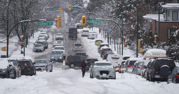
It’s been a snowy, blustery and bone-chilling winter for many Canadians. British Columbians were digging out of abnormal snow in early March. The Prairies have seen a good dose of good old-fashioned winter, and extreme cold warnings were issued in Ontario, Quebec and the Atlantic provinces as well. Then there was the Christmas travel period thrown into chaos by winter storms – a huge mess from coast to coast.
One thing that points to all that cold weather is La Niña. It’s a climate pattern that results in cooler ocean waters building up off the coast of Ecuador and Peru. That sets off a change to atmospheric conditions further north, resulting in cooler air over the west coast of North America, and drier air in the southern United States.
Now, that period of cooling is weakening, which could usher in a prolonged period of extreme heat – possibly even pushing average global temperatures past that all-important threshold of 1.5 C beyond which, scientists fear, the planet will cross irreversible tipping points.
La Niña is a climate phenomenon that results in cooler-than-normal waters appearing off the coast of South America, near Ecuador and Peru.
La Niña occurs when stronger trade winds push warm water away from South America and toward Australia and Indonesia across the equatorial Pacific Ocean, which leaves a buildup (or upwelling) of cold water.
That cooler air inhibits cloud formation, and rain, in the eastern Pacific near South America. It also generates a lot of rain in the western Pacific over Indonesia. Those anomalies push the jet stream – high-altitude bands of fast-flowing air that control the weather – further north. Changes in atmospheric conditions have a spillover effect on weather patterns over North America that can last for months.
La Niña is usually associated with a period of cooler temperatures, especially in Western Canada, says Bill Merryfield, a research scientist with Environment Canada’s climate modelling office. He says La Niña’s chilling effect might have tempered the wildfire season in B.C. last year.
But the impacts can be felt even months after La Niña starts to dissipate, which has already started. Because of those lingering effects, Merryfield says Environment Canada is predicting a cooler spring on the west coast of Canada. But that doesn’t mean we aren’t in store for much more heat in the not-so-distant future.

The main U.S. indexes were on track to open higher on Monday after President Donald Trump said he would order the military to postpone strikes against Iranian power plants.

U.S. President Donald Trump said that the suspension of his threat to attack power plants was “subject to the success of the ongoing meetings and discussions.”

Israeli Prime Minister Benjamin Netanyahu claimed Israel and the U.S. were well on their way to achieving the war’s goals and implored the international community for more support.

Israeli Prime Minister Benjamin Netanyahu claimed Israel and the U.S. were well on their way to achieving the war’s goals and implored the international community for more support.

Canadians are preparing to sail to Gaza with an aid flotilla, despite expectations of interception and detention by Israeli forces

Trump also said ICE could carry out arrests at airports, including targeting undocumented immigrants, and made specific references to migrants from Somalia.

Trump says U.S. is nearing its Middle East objectives as allies condemn Iran’s actions in the Strait of Hormuz and warn of global energy impacts.

NATO’s top commander, Gen. Alexus Grynkewich, confirmed earlier Friday that the alliance has pulled several hundred personnel out of Iraq and relocated them to Europe.

The Epstein files revealed consistent communication between the royal and Epstein, including after he was convicted of child sex trafficking offences in 2008.

Prime Minister Mark Carney endorsed a statement after it was released by allies Thursday, expressing willingness to contribute to efforts to reopen the Strait of Hormuz..

James 'Jimmy' Gracey was reported missing after he didn't return to the short-term rental where he was staying with friends during spring break.

The Mina Al-Ahmadi refinery in Kuwait, which can process some 730,000 barrels of oil per day, is one of the largest in the Middle East.

U.S. intelligence, military and law enforcement officials unanimously agreed that an intelligence assessment doubting a foreign role in the 'Havana syndrome' should be withdrawn.