IIT Delhi team makes first hi-res landslide risk map for India Premium
The Hindu
An IIT Delhi team has created India's first national landslide susceptibility map in high resolution, using both ground-level data and ensemble machine-learning models, to identify areas where a landslide risk has thus far not been recognised.
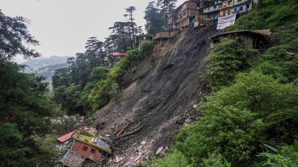
In late 2023, torrential rain during the northeast monsoon triggered heavy floods and landslides in multiple States in North India, killing hundreds of people. Given the number of fatalities due to landslides in India, a national landslide susceptibility map can help identify the most dangerous areas and help allocate resources for mitigation strategies better.
Unfortunately, India didn’t have a landslide susceptibility map at the scale of the whole country then – so Manabendra Saharia, an assistant professor in the civil engineering department and head of the HydroSense Lab at IIT Delhi, wanted to make one.
Landslides are a unique and deadly problem in India. Unlike floods, they’re less widespread and harder to track and study with satellites. Landslides happen in very localised areas and affect only about 1-2% of the country. As a result, there is much less data of sufficient quality for typical machine-learning models to work with.
“We wanted to build a national landslide susceptibility map that not only uses the data but also uses the latest techniques,” Dr. Saharia said.
So his graduate student Nirdesh Sharma first collected the data of known landslides in the country. He obtained nearly 1.5 lakh such events via the Geological Survey of India (GSI) and other, including global, sources.
Then, the duo collected information on the factors that rendered an area susceptible to landslides. Some of them are soil cover (or the type of soil in the area), the number of trees covering the area, and how far it is from any roads or mountains. The fewer trees there are in a place, the closer it is to road-building activity, and the steeper the local slope, the more unstable the place will be and thus more prone to landslides.
The two researchers gathered information from across the country on 16 such factors, which they called landslide conditioning factors. They said GeoSadak, an online system that has data on the national road network in India, was particularly helpful because it displayed data on roads even outside cities.

In its first edition, the Madras Art Salon spotlights the works of journalist and artist Narayan Lakshman at The Botanical Club, a social space in the British Deputy High Commission, Chennai

Cholesterol enhances melanoma cell invasion by making nuclei squishier, revealing a potential treatment target in cancer progression.

The designers reinterpret the Swedish artist’s symbolic forms and colour energy through contemporary resortwear silhouettes

Discover the inspiring legacy of Bibha Chowdhuri, a pioneering woman in physics and a trailblazer in STEM history.

Discover the inspiring legacy of Bibha Chowdhuri, a pioneering woman in physics and a trailblazer in STEM history.

Ashdeen’s Spring 2026 collection features saris inspired by the designer’s Parsi gara archive

Red ochre burials, ritual markings and myths across cultures show that red repeatedly marks liminal thresholds such as puberty, sacrifice and death; anthropologists argue that the colour functions as a technology of collective ritual and value, binding communities through shared symbolic acts

India approves 23 institutions for quantum labs under the National Quantum Mission, aiming to advance quantum technology and research.

India approves 23 institutions for quantum labs under the National Quantum Mission, aiming to advance quantum technology and research.

The Gaza conflict exacerbates environmental damage, emitting millions of tonnes of CO2 and threatening climate stability in West Asia.

Chefs and cookery experts share smart kitchen hacks, hybrid cooking methods and appliance tips to help households reduce LPG use without compromising on food

Discover groundbreaking research on Titan's lakes, bat vaccinations, and the unique aroma of ripening bananas in just one minute.

IRSO's NavIC system faces challenges as the last atomic clock fails, reducing operational satellites for navigation services.