Hurricane Otis’ growth to Category 5 storm surprised forecasters. Why?
Global News
The storm, which has killed at least 27 people, was originally forecast to hit the southern-Pacific region of Mexico as weak hurricane.
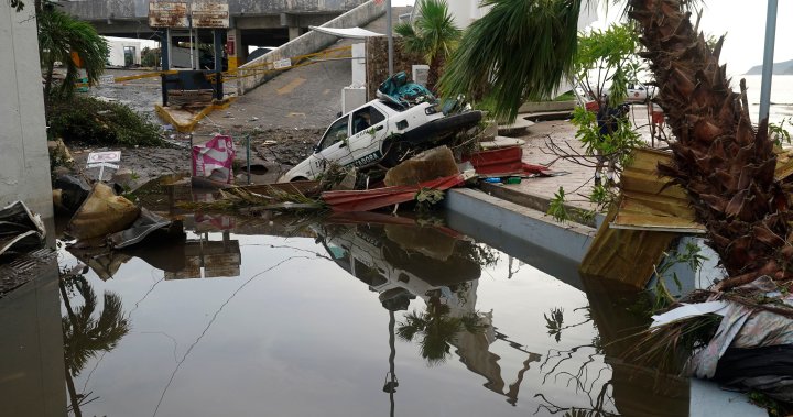
Hurricane Otis slammed into the southern-Pacific part of Mexico early Wednesday morning, downing power lines in communities including the popular tourist city of Acapulco. The hurricane damaged buildings and flooded roads and it’s left many wondering how forecasters didn’t see the Category Five storm coming.
The storm, which has killed at least 27 people, was originally forecast earlier this week as one that would hit the region as a weak hurricane.
It took many by surprise on Tuesday evening when it rapidly strengthened from a tropical storm to a powerful hurricane as it tore along the southern coast.
Daniel Brown, a senior hurricane specialist at the National Hurricane Center in Miami, Fla., told Global News that the modelling did not give meteorologists indication there would be such a significant strengthening. He said while there was initially a “vertical wind shear” over the storm, it appeared to have “relaxed” by Monday night.
“Rapid strengthening is one of the most difficult aspects to forecast of hurricanes,” he said. “We have gotten better in very recent years of forecasting rapid strengthening. But this really was an extreme case.”
Brown said “rapid strengthening” is defined as about a 35 mile-per-hour, or about 56 kilometre-per-hour, increase in winds over a 24-hour period, adding Otis “essentially doubled, almost tripled that rate of intensification” before it hit the coast of Mexico.
According to Global News chief meteorologist Anthony Farnell, the storm — which reached winds of approximately 265 km/h — saw a ramp-up of about 125 km/h in just 12 hours.
What made the storm worse, especially for those in Acapulco, was that it hit at night, making it more difficult for people to get advance warning whereby they would have time to get to higher ground, according to Farnell.

Iran's foreign minister said the U.S. attacked Kharg and Abu Musa islands from locations in the United Arab Emirates, a claim the UAE rejected.

Citing "a more contested environment", British Prime Minister Keir Starmer and his Irish counterpart Micheal Martin said the exercises would begin in September.

Only one in four (23 per cent) Canadians approve while, 16 per cent are unsure either way. Forty-two per cent were found to strongly disapprove.

Countries around the world are grappling with skyrocketing costs for key commodities like oil and fertilizer as the war with Iran continues to upend global trade.

The U.S. Central Command said the crash followed an unspecified incident involving two aircraft in “friendly airspace,” and that the other plane landed safely.

Water treatment centres in the Persian Gulf region are under threat amid the Iran war, with desalination plants in areas like Bahrain taking damage from strikes.

John Gradek said that the price of jet fuel is up about 30 per cent and the cost of fuel represents about 30 per cent of an airline's operating costs.

Iran's unrelenting attacks on shipping traffic and energy infrastructure in the Persian Gulf pushed oil back above $100 a barrel on Thursday.

Concerns were raised in a document sent to British Prime Minster Keir Starmer in December 2024 when he was considering appointing Peter Mandelson.

Canada and a group of dozens of other countries have agreed to release 400 million barrels of oil from their strategic reserves as the Iran war threatens the global supply.

Iran's military command said on Wednesday the world should be prepared for oil to hit US$200 a barrel, as three more ships came under attack in the blockaded Gulf.

Iran launched new attacks against Israel and Gulf Arab countries, while Israel carried out airstrikes on Iran and Lebanon, where it is battling Hezbollah militants.

The department said it is also seeing fewer Canadians take government-assisted travel options as flights gradually resume in certain parts of the region.