Heavy snowfall persists in N.S., will continue until Monday: Environment Canada
Global News
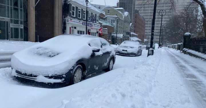
Environment Canada says up to 80 cm of snow could fall in some parts of Nova Scotia this weekend creating poor driving conditions, with visibility reduced to near zero at times.
Nova Scotia residents awoke to a winter wonderland on Saturday as a “prolonged period of snow” is expected to persist throughout the weekend and into Monday. Some areas of the province are expected to get up to 80 centimetres of snowfall.
In an Environment Canada snowfall warning issued for Central Nova Scotia, which includes the Halifax area, the weather agency noted that there will be a brief break in snowfall overnight on Saturday before intensifying again on Sunday afternoon; 20 to 30 centimetres of snow is anticipated during this period.
“The highest accumulations are expected during the day today,” the statement read, adding that the snow will be wet and heavy which could result in a strain on power lines.
Environment Canada said up to 80 centimetres of “or possibly higher” is expected in eastern mainland Nova Scotia and Cape Breton Island, with 30 to 40 centimetres of snow overall in central Nova Scotia.
For most of northeastern Nova Scotia, which includes Cape Breton, visibility could be reduced to near zero during periods of heavy and blowing snow.
According to a winter storm warning issued for the area, “20 to 30 cm of snow can be expected by Sunday morning, with a further 30 to 50 cm possible by Monday morning.”
“Conditions will deteriorate further on Sunday as winds increase and snowfall rates intensify, with blowing snow reducing visibilities.”
The snow is expected to taper to flurries throughout the day on Monday.

Finance Minister François-Philippe Champagne says the government has found ways to cut spending by $60 billion but cautions that published spending cuts require important context.

Three Canadians from Quebec who were stranded in the Persian Gulf since Feb. 28 have returned home following a coordinated repatriation effort.

Federal departments announced that they plan to cut more than 12,000 jobs over three years as part of the Carney government’s spending review plan.

Canada’s Integrated Threat Assessment Centre says the U.S.-Israeli war against Iran has heightened an already present threat against Jewish Canadians and public officials.

Edward Warner, his wife Tania and his seven-year-old step-daughter Ayla were coming back from a friend's baby shower on Saturday when they went through an ICE checkpoint in Sarita.

A fire chief from a village that battled flames during Saskatchewan's destructive wildfire season last year says the province's latest budget does not provide enough funding.

Manitoba’s upcoming budget will include more child care funding and a smaller deficit, as the NDP government aims to balance finances by 2027.

A member of the Royal Canadian Air Force in Winnipeg has just been crowned the World's Strongest Firefighter, outlifting athletes from around the world.

Muslims across Canada are celebrating Eid al-Fitr while some reflect on conflict affecting loved ones abroad, as leaders highlight unity, charity and renewal.

The Iran war has raised the price of crude oil beyond US$110 per barrel in international markets, spurring affordability concerns in Canada and around the world.

The statement from Global Affairs Canada comes a day after U.S. intelligence leaders unanimously testified that reports denying foreign involvement should be retracted.

It may be the first day of spring, but Ontario’s long winter isn’t over, with more snow and icy conditions expected before a full warm-up arrives

The policy is something of a reversal from a government that killed a similar idea shortly after taking power. Back in 2019, the province said the policy would be unenforceable.