Explained | The escalation on the India-China border Premium
The Hindu
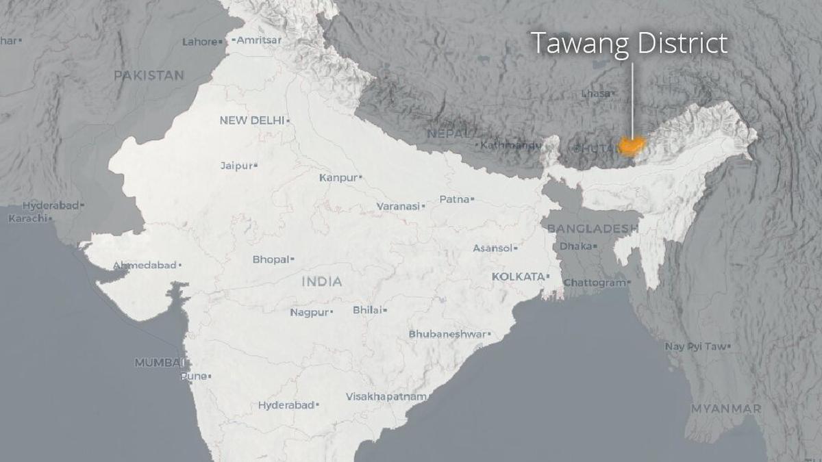
What has the Australian Strategic Policy Institute found about the clash between Indian and Chinese troops in the Yangtse area of the Tawang region in Arunachal Pradesh? What does satellite imagery show?
The story so far: On December 9, 2022, Indian and Chinese troops clashed in the Yangtse area in the Tawang region along the India-China border. The confrontation in Tawang was the most serious skirmish between the two sides since the Galwan Valley clash in 2020. The Australian Strategic Policy Institute (ASPI) has found that the skirmish that took place in December was aided by new road infrastructure on the Chinese side, part of rapid infrastructure development by China along the border in this region allowing access to key locations on the Yangste plateau more easily than a year ago. Through satellite imagery, ASPI examines the terrain in which the clash took place along the India-China border, where tens of thousands of Indian and Chinese troops continue to be deployed.
Tawang is a strategically significant Indian territory wedged between China and Bhutan. The region’s border with China is a part of the de facto but unsettled India-China border, known as the Line of Actual Control, or LAC. Within Tawang, the Yangtse plateau is important for both the Indian and Chinese militaries.
With its peak at over 5,700 metres above sea level, the plateau enables visibility of much of the region. Crucially, India’s control of the ridgeline that makes up the LAC allows it to prevent Chinese overwatch of roads leading to the Sela Pass — a critical mountain pass that provides the only access in and out of Tawang. India is constructing an all-weather tunnel through the pass, due to be completed in 2023. However, all traffic in and out of the region along the road will still be visible from the Yangtse plateau.
India’s defences along the plateau consist of a network of six frontline outposts along the LAC. They are supplied by a forward base about 1.5 kilometres from the LAC that appears to be approximately battalion sized. In addition to this forward base, there are more significant basings of Indian forces in valleys below the plateau.
Although Indian forces occupy a commanding position along the ridgeline, it is not impregnable. The access roads leading from the larger Indian bases are extremely steep dirt tracks. Satellite imagery shows that these roads are already suffering from erosion and landslides due to their steep grade, environmental conditions and relatively poor construction. While China’s positions are lower on the plateau, it has invested more heavily than the Indian military in building new roads and other infrastructure over the past year.
Several key access roads have been upgraded and a sealed road has been constructed that leads from Tangwu New Village to within 150 metres of the LAC ridgeline, enhancing China’s ability to send People’s Liberation Army troops directly to the LAC. There is also a small PLA camp at the end of this road. It was the construction of this new road that enabled Chinese troops to surge upwards to Indian positions during the December 9 skirmish.
The skirmish that took place between Chinese and Indian troops on December 9 on the Yangtse plateau was aided by this new infrastructure development. Strategically, China has compensated for its tactical disadvantage with the ability to deploy land forces rapidly into the area. In small skirmishes, the PLA remains at a disadvantage because more Indian troops are situated on the commanding ridgeline that makes up the LAC. But in a more significant conflict, the durable transport infrastructure and associated surge capability that the PLA has developed could prove decisive, especially in contrast to the less reliable access roads that Indian troops would be required to use. Recent developments around Galwan and Pangong-Tso have shown that where there is the political will, tense situations along the LAC can be disengaged with the involvement of both sides. In these areas, successful redeployment to positions back from the LAC has greatly reduced the risk of conflict.

Why Pushkar continues to draw crowds each year

Dakshina Kannada groundwater levels in ‘safe’ category, only 45% utilised: Union Jal Shakti Ministry
Dakshina Kannada's groundwater levels remain safe, with only 45% of extractable resources currently utilized for various needs.

Commuters and activists demand signals, speed breakers and other safety measures at Kolapakkam junction on Vandalur-Kelambakkam Road. During peak hour, this intersection becomes a major traffic bottleneck and cannot do without police presence

An increasing number of colleges in Chennai run study circles on their premises to help students prepare for UPSC and TNPSC exams

Inspired by deeply personal memories, says maker of Telugu short selected for Sundance Film Festival
Telugu short film "O’sey Balamma," inspired by childhood memories, selected for Sundance Film Festival 2026, says creator Nimmala Raman.

Bengaluru deploys 20,000 police for New Year celebrations, with heat maps for crowd monitoring and enhanced safety measures.

India’s election rulebook governs a campaign ecosystem that no longer runs only on parties and candidates, as political persuasion shifts to platforms and intermediaries operating outside formal regulatory structures.

S. Krishnaswamy, acclaimed filmmaker and Padma Shri recipient, passes away, leaving a legacy of over 900 impactful documentaries.

Shorts News:Three Tamil Nadu fishermen arrested by Sri Lankan Navy

BJP's Nainar Nagenthran claims the government orchestrated the Karur stampede, questioning the Chief Minister's actions post-tragedy.

Families of Red Fort blast victims await government compensation, facing financial struggles and lack of communication from officials.

Uttar Pradesh deletes 2.89 crore names from draft voter list; voters can contest deletions starting January 1, 2026.

The Union and State governments provided support in several ways to the needy people, but private institutions should also extend help, especially to those requiring medical assistance, said C.P. Rajkumar, Managing Director, Nalam Multispeciality Hospital, here on Saturday. Speaking at a function to honour Inspector General of Police V. Balakrishnan and neurologist S. Meenakshisundaram with C. Palaniappan Memorial Award for their contribution to society and Nalam Kappom medical adoption of Type-1 diabetic children, he said the governments implemented numerous welfare programmes, but the timely help by a private hospital or a doctor in the neighbourhood to the people in need would go a long way in safeguarding their lives.